To put the locations featured on this page in the proper context, it is recommended that you read the Springfield page first.
The Battle of Springfield was fought on June 23, 1780.
Details about the main events of the Battle of Springfield can be found on the Springfield page.
The entries on this page deal only with the portion of the fighting that occurred in what is now Millburn.
The area that today makes up Millburn was then part of Springfield; Millburn was formed from parts of Springfield in 1857. [1]

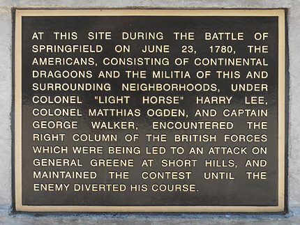
Plaque on the Vauxhall Bridge on Vauxhall Road
at the border of Union and Millburn, across from Milburn Mall
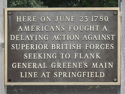
Plaque about 100 feet from the bridge in front of a parking lot
at
the corner of Millburn Ave. and Vauxhall Rd.
Battle of Springfield Markers
• Vauxhall Bridge on Vauxhall Road
at the border of Union and Millburn, across from Millburn Mall
• 100 feet from the bridge in front of a parking lot at the corner of Millburn Ave. and Vauxhall Rd.
Map / Directions to these Markers
Map / Directions to all Union NJ Revolutionary War Sites
At the Battle of Springfield, British forces made their main attack on American forces under General Nathanael Greene over the Rahway Bridge into Springfield. At the same time, they made an attempt to flank Greene's forces by having their right column make an attack over the bridge that was here on Vauxhall Road over the Rahway River. [2] The British fought their way past the bridge, but their advance was stopped about a mile from here, by where the Millburn Town Hall now stands. (See next entry below.)
A modern bridge spans the Rahway River here today. The two markers pictured above describe the fighting that occurred at this location during the Battle of Springfield.

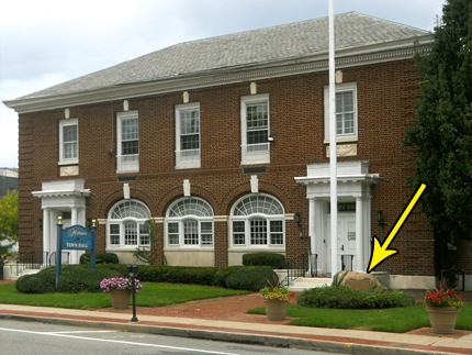
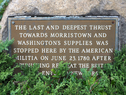
Last British Thrust Marker
In front of the Millburn Town Hall
375 Milburn Ave.
Map / Directions to the Last British Thrust Marker
Map / Directions to all Millburn Revolutionary War Sites
British forces fought their way past the Vauxhall Road bridge (see above entry), and the American forces made a fighting retreat, falling back about mile to a second bridge over another branch of the Rahway River, where the British advance was stopped. In present day, that other branch of the Rahway River goes under Millburn Avenue near Main Street. Just past there is the Millburn Town Hall, where a boulder monument in front of the building marks the location. [3]
After their defeat at the Battle of Springfield, the British army made no further larges-scale attempts to invade New Jersey. While skirmishes and attacks by raiding parties would occur in New Jersey until the end of the war in 1783, the Battle of Springfield ended up being the last major Revolutionary War battle fought in the North. The emphasis of the fighting shifted to the southern states, culminating in the decisive Battle of Yorktown sixteen months later on October 19, 1781.

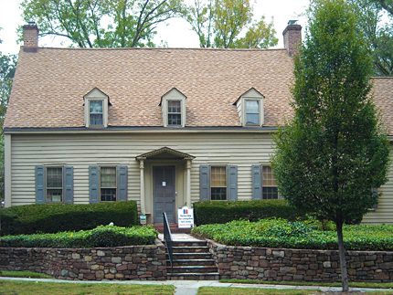
Hessian House
155 Millburn Ave.
Now used as the headquarters of
Joseph P. Miele Center for Substance Abuse Prevention.
Map / Directions to the Hessian House
Map / Directions to all Millburn Revolutionary War Sites
This house was built in 1730, and so was here on June 23, 1780 as fighting of the Battle of Springfield went on around it. (The house is less than 500 feet from the Vauxhall Bridge, described in the entry at the top of this page.)
The house is known as the Hessian House because two deserter Hessian soldiers may have hidden here
during the Battle of Springfield. In her 1957 work, A History of Millburn Township, Millburn historian Marian Meisner wrote:
"At least two boys, the VanWert brothers, deserted that day, and hid until after their companions had left the area. They are supposed to have hidden in the attic of [this] house. Another version of the old story says that they hid in the barn on the Stephen Meeker farm on Glen Avenue near Farley Road, but the house at 155 Millburn Avenue has long been known as 'The Hessian House,' and majority opinion gives that house the distinction of hiding the boys on the night of June 23, 1780." [4]

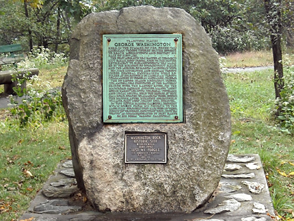
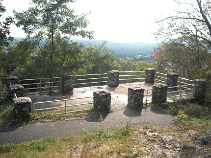
Washington Rock
South Mountain Reservation
At the end of Crest Drive within the park.
Map / Directions to Washington Rock
Map / Directions to all Millburn Revolutionary War Sites
If you follow Crest Dr. within South Mountain Reservation, you will come to Washington's Rock. A boulder plaque tells of the events of June 1780, related to the Battle of Connecicut Farms and the Battle of Springfield. There is an observing platform by the edge where you can take in the view.
The text on the plaque reads:
"Tradition places George Washington here, in the summer of 1780, observing American troops thwart British efforts to reach Morristown and destroy his base of supplies. The first advance was halted at Connecticut Farms, now Union, June 7th. The British retirement to Elizabethtown was marked by the burning of Connecticut Farms and the murder of Parson Caldwell’s wife. On June 23rd British and Hessian troops under General Knyphausen were repulsed at Springfield by American troops commanded by General Nathaniel Greene. The 2nd Rhode Island regiment, under Col. Angell, was stationed at the easterly bridge over the Rahway River, on the main road (Morris Avenue). Major 'Light Horse Harry' Lee, with Colonial veterans and local militia, held the bridge at Vaux Hall Road. Forced to abandon their effort, the British, after burning Springfield Village, quit New Jersey soil forever. In this battle Parson Caldwell brought hymn-books from his church to the American gunners who had used up their supply of wadding, shouting ';Boys, Give ‘em Watts!' as commemorated by Bret Harte in his poem 'Parson Caldwell'." [5]
White Oak Ridge Cemetery
Parsonage Hill Rd. and White Oak Ridge Rd.
Map / Directions to White Oak Ridge Cemetery
Map / Directions to all Millburn Revolutionary War SitesThis small cemetery on the corner contains about thirty-five grave stones. The majority of those buried here are named Parsil, although some of the gravestones spell it as "Parcell" or "Parcil")
Two brothers who fought and died in the Revolutionary War are buried here: [6]
Captain Thomas Parcell (Parsil)
Died July 4, 1778, Aged 34Nicholas Parcell (Parsil)
Died June 10, 1780, "in the 33rd year of his age"
1. ^ The act to create Millburn from parts of Springfield was approved by the New Jersey State Legislature on March 20, 1857. The text of the act can be read in:
Acts of the Eighty-First Legislature of the State of New Jersey (New Brunswick: A. R. Speer, 1857) p. 379-381 Available to be read at Google Books here.
2. ^ Thomas Fleming, The Forgotten Victory (New York: Reader's Digest Press, distributed by E. P. Dutton & Co., Inc, 1973) p. 239, 243, 266-271
3. ^ Thomas Fleming, The Forgotten Victory (New York: Reader's Digest Press, distributed by E. P. Dutton & Co., Inc, 1973) p. 268-271
• Some of the text of this boulder plaque is hidden in the photo because of the shrubbery. The full text of the plaque reads,
"The last and deepest thrust towards Morristown and Washington's supplies was stopped here by the American militia on June 23, 1780. After a punishing retreat, the British never entered New Jersey again in force."4. ^ Marian Keefe Meisner, A History of Millburn Township, 1957
A note on the title page of the original edition of this work states, "Written on the occasion of the celebration of the Centennial of Millburn Township, and serialized in the Millburn and Short Hills Item commencing January 24, 1957."
• The book was later updated by Marian K. Meisner in 1976 for the Millburn Township Bicentennial Committee.
This updated version is available as a PDF on the Millburn Free Public Library website here /Quoted Hessian House text is on page 62 of the PDF
(PDF states "Jointly published by the Millburn/Short Hills Historical Society and the Millburn Free Public Library. Copyright, July 5, 2002.")5. ^ Text of boulder plaque at Washington Rock.
A smaller plaque underneath the main plaque reads, "Washington Rock Historic Site rededicated by the 1st Mountain Chapter, NJ Society Sons of The American Revolution." It is unclear if the 1st Mountain Chapter placed the main plaque, which appears to have been placed much earlier.6. ^ • Date and age information from the gravestones of Thomas and Nicholass Parcell